Below is an archive of Peter Dovak´s 220 metro and light rail systems. Peter drew these shrunken and simplified maps of the world´s transit systems in 2016 and updated them until his sad and untimely death in 2017. Since then, Peter´s website and work has not been available online, and I would like to share […]
One of the more impressive state owned and operated railway networks in the USA, is that of NJ Transit. With about 690,000 daily workday passengers, 209 million annual trips and a thousand miles of tracks it ranks it ranked the 6th Transportation Authority in the country by Annual Trips, with 206 million and second by […]
Today Utrecht boasts excellent bicycle infrastructure, a rebuilt canal (see bicycledutch.wordpress.com’s article) and three light rail lines. The light rail system was introduced forty years ago in 1983 and consists of two diameter lines (21 & 20) and a radial line (22) that terminates at Utrecht Central Station. In Dutch it is named Utrechtse sneltram […]
A different and more simple approach to showing the travel time than an isochrone map, is a travel time polar diagram. Instead of defining the x and y coordinates in cartesian plane a polar diagram gives you the direction and length of a point. In this case the length would be the travel time and […]
TransportationBaltimoreBostonhigh speed railNew York CityNortheastPhiladelphiaRailwaySwedentrainTransitUSA
If there is one railway in the United States of America that currently qualifies as a high speed rail line, then that would be the Northeast Corridor (abbreviated NEC) that connects Boston – New York City – Philadelphia – Baltimore – Washington D.C.. These cities alone have a population of 12 million people, but if […]
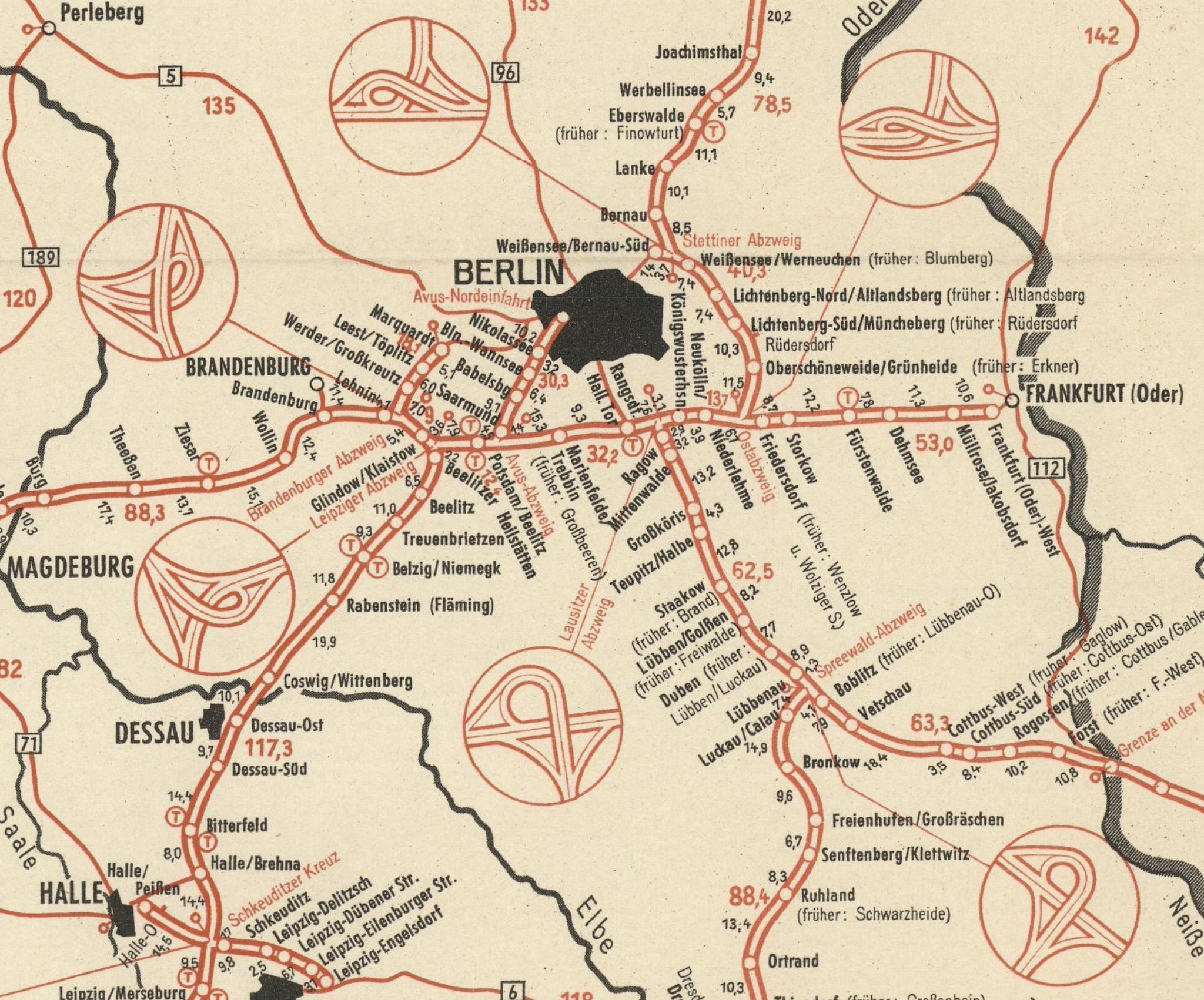
The David Rumsey Map Collection recently digitized and shared online ADAC‘s Autobahn-Karte from 1950, showing the then still relatively sparse autobahn (interstate) map of Germany. See their online map for a comparison of Germany’s autobahn network today. The 1950 map includes little call-outs showing the intersections of the different autobahn junctions. Above a ring of […]
An interesting quirk of history, let the isolated Basque language establish itself in the New World shortly after Christopher Columbus’s rediscovery. Basque fishermen from Spain and France, who had a long tradition of fishing and whaling in the Atlantic Ocean, where among the first Europeans to establish a presence on the American continents. (There were […]
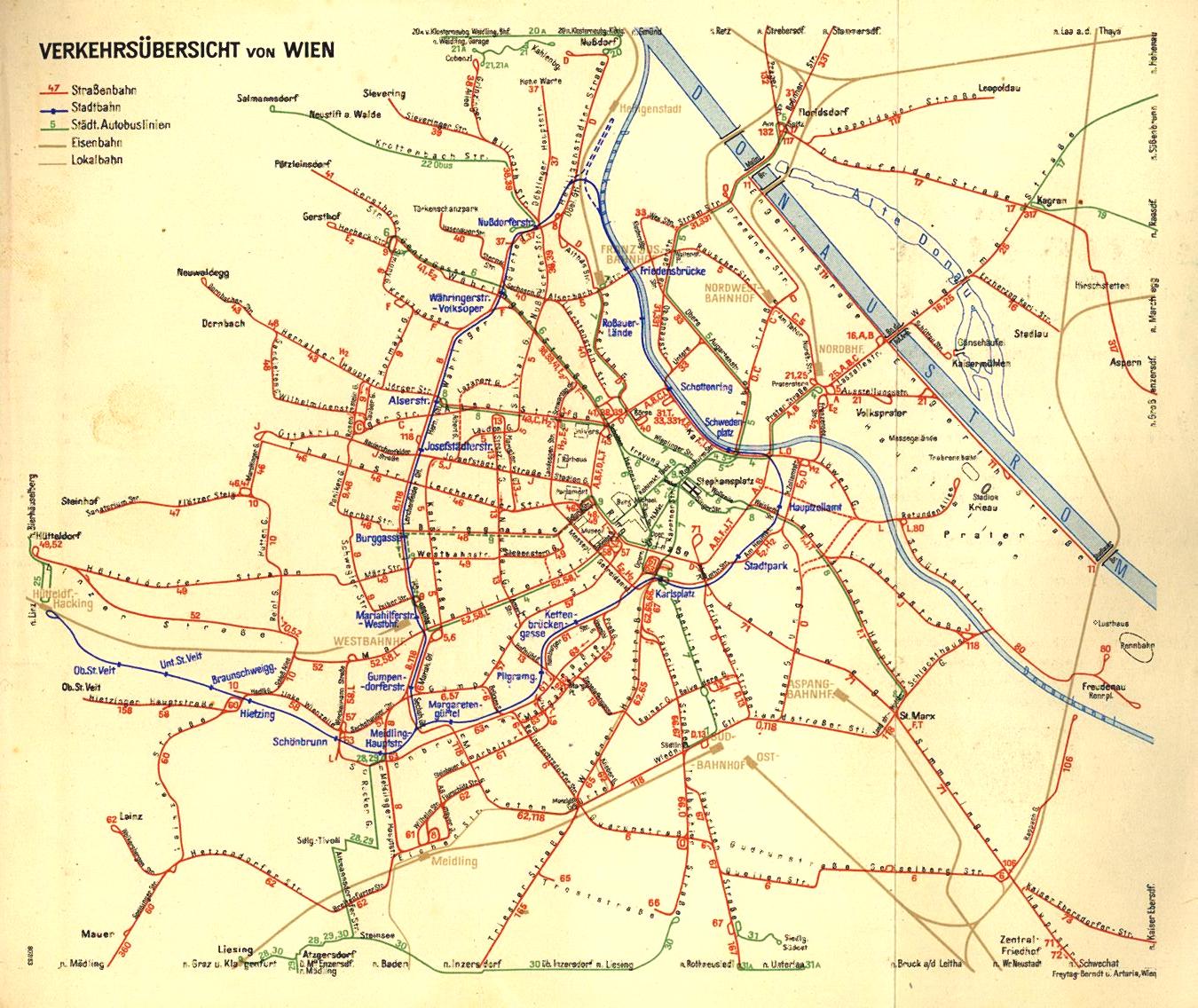
After 40 years without having a transit network diagram for all bus and tramway lines, but instead relying on a route map superimposed over a city map, Vienna’s Wiener Linien commissioned a network transit diagram in 2016. In comparison to the old diagrams in use until the 1970s, the new diagram forced the lines into […]
Direct Network A Direct Network (or Point-to-Point Network) connects ever single station (N) to every other single station by a route (R) which has only one route segment (RS). R=RS=(N*(N-1)/2=(N2-N)/2 The detour ratio of this kind of service is 1:1 making it attractive to potential passengers but usually expensive and increasingly complex. With a increase of […]
Burtă, Pântece, Stomac? The map above is from the Romanian Linguistic Atlas showing the variants of the word “belly” and their distribution. It discusses six different names for the “bowels” BURTĂ of unknown etymology; possibly akin to Albanian bark, Proto-Indo-European *bʰer- ‘to carry’. (English cognate belly??) PÂNTECE from Latin pantex, (English cognate paunch) FOALE from Latin […]
This is post that discusses Linear Networks with Feeder Lines, for a Overview of Network Types read further here. Linear Network with Feeder Lines Vuchic [1] defined two types of Linear Networks, Trunk Line with Feeders and Feeders with a Trunk Section. Below are four examples of Linear Network with Feeder Lines that differentiate from each other […]
Flexible Routes can add a large area covered by the network with the advantage of reducing walking distances for potential passenger. Flexible Routes originate from one point (e.g. train or metro station) leave in the direction of a destination (a particular settlement or another station). In some cases the route is predefined and merely the service […]
This post will discuss Minimal Transit Networks, for other network types see an Overview of Network Types. For route types see an Overview of Route Type Geometry. Minimal Network This is the most simple type of network and consists of one route (R=1) that connects all serviced stations. Every station (N) is connected to two others by […]
In this page I want to give an overview of what types of transit networks that there are. Since the original page became quite long, each network category has a separate post which discusses the types of transit networks together with fictional example for each. Fictional examples are drawn again on the 1905 Königsberg map background […]