We had an extraordinary winter in Utah. There was almost no snow. We had only one measurable snow storm, but the snow melted within the next day. It was cold enough to snow, but it just never snowed. This is an interesting ice design on a stream that comes from Big Springs located above the South Fork of the Provo Canyon. We spend most of our time walking around the snow in the muddy ground.
The maple trees are almost the last to shed their leaves for the winter. But being among the last does not mean they are any less colorful than all the others. We are now prepared for winter as we see the last leaves fall and snow in the forecast.
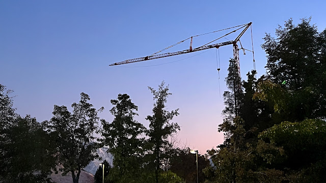
Construction on the Arts Building continues. This is a nighttime shot of one of the cranes on the construction site. Brigham Young University November 9, 2024.
You can see a few stars shining through the bright color of the Aurora Borealis as seen over the mouth of Rock Canyon, just east of Provo but actually in the city boundaries. It was strange because we could not see the color with our eyes but the iPhone camera could. This photo was taken in almost complete darkness with an iPhone 15 Pro Max. The camera was hand held and the software compensated for any hand movement during the 2 or 3 seconds it took the camera to take the photo.
RootsTech 2025 will be live on March 4th through the 6th, 2025 in Salt Lake City. Utah at the Salt Palace. You can register today at RootsTech.org. You can also view all currently posted videos and announcements for free on the RootsTech.org website.
RootsTech 2025 is now open for registration. Take some time to explore the website with thousands of videos. You can attend online for free or come to the live conference on March 6th to 8th, at the Salt Palace in Salt Lake City, Utah.
We had a short trip up the Rock Canyon Campground road (Kyhv Peak Road) to see the beginning of the fall leaves. The road past the pavement is rough and rocky with lots of dust. It is worth the drive. We got our car washed when we got back to the Valley.
The iconic Salt Lake City, Utah Temple of The Church of Jesus Christ of Latter-day Saints is still ongoing. Here is an article about the project. "Salt Lake Temple and Temple Square Renovation Updates." The large red, white, and blue lights are large cranes used in the construction.
In the middle of a hot summer, it is always a good idea to remember that, unless you live in the lower desert, Fall will come and the temperatures will drop.
I am publishing a series of short videos about the upcoming RootsTech 2025 Conference. It isn't too early to start making plans to come to Salt Lake City to the in-person conference. Check the RootsTech website for more information about the conference.
The demolition of the Provo, Utah Temple is almost complete. This video shows a view of the entire temple lot. We do not yet know where the new Provo Rock Canyon Temple will be built. I suppose we will know when they start excavating the basement. It was a lovely day but sad.
It is warm and beautiful day but very sad. This is what is left of the ongoing demolition of the Provo, Utah Temple. I expect that this all we gone or in piles by the end of next week. You can see the base of the spire in the center of the ruin. It was on the roof and keeps falling down in the middle as the temple is demolished.
The Provo Utah Temple closed on February 24, 2024 for reconstruction and will be renamed the Provo Utah Rock Canyon Temple. The temple has served BYU students, missionaries, and local Latter-day Saints for more than 50 years. The actual reconstruction began the week of April 14th through the 20th with tree removal and site demolition. The Angel Moroni statue was removed on 18 April 2024. This is a short video showing the removal.
Using a colander or strainer, you can see miniature images of the solar eclipse. We had a few clouds but a good view of the sun. Not enough coverage to make the light go weird however.
Cylindropuntia fulgida or Hanging chain cholla or jumping cholla
Cylindropuntia fulgida, also referred to as the hanging chain cholla, is a remarkable cactus native to the Sonoran Desert and the Southwestern United States. Its greatest range encompasses nearly all of Sonora, except for the Sierra Madre Occidental cordillera on the east, and extends into northern California. In the Southwestern United States, you can find it in the Colorado Desert of California and various locales in Arizona. It even ventures into the Mojave Desert in southern Nevada and Utah, as well as the Great Basin Desert in southern Utah. The jumping cholla thrives in arid environments, where it forms striking forests of interconnected plants spanning vast areas1.
The jumping cholla is an arborescent (tree-like) cactus with a low-branching trunk. Its stems are light green, tuberculate (covered in wart-like projections), and measure 6 to 9 millimeters in length. These stems give rise to drooping branches adorned with silvery-yellow spines, which darken to gray as they age. The spines form a dense layer, obscuring the stems and creating an otherworldly appearance. As the spines fall off from older parts, the bark reveals a rough, scaly texture. The jumping cholla blooms in mid-summer, displaying white and pink flowers streaked with lavender. Interestingly, it opens its flowers precisely at 3:00 p.m. solar time, a quirk noted by naturalists1.
Cylindropuntia fulgida grows at elevations ranging from 300 to 1,000 meters (980 to 3,280 feet). While the name “jumping cholla” specifically applies to this species, it is also used more broadly for all chollas. The plant can reach heights of up to 4 meters (13 feet) and forms dense, sprawling clusters. Its cylindrical trunk holds multiple low, drooping branches, creating a distinctive silhouette. Beware of those spines—they detach easily and seem to “jump” onto unsuspecting passersby. So, if you encounter a jumping cholla, admire its unique beauty from a safe distance.
We had a very warm Fall that suddenly jumped into Winter. Some of the plants hardly had time to process the event and their leaves were still in place when the snow started. A few of the plants turned lovely colors but others turned a dull brown and are still clinging to their branches. Now we move into snow.
The skeletons in Mexico dressed up and displayed are part of the Day of the Dead (Spanish: Día de los Muertos) celebration, which is a pre-Hispanic tradition that honors the cycle of life and death. The skeletons are called calacas, which are whimsical representations of the deceased in various scenes of everyday life. They are often made of papier-mache, wood, clay, or sugar or in this case, iron.
The calacas are displayed in homes, altars, streets, and cemeteries during the Day of the Dead, which takes place every year on November 1 and 2. They are meant to celebrate and remember the lives of the departed, as well as to mock death and show that it is not something to be feared. The calacas are also decorated with bright colors and flowers, especially marigolds, which are believed to attract the souls of the dead with their scent. The calacas are a unique and festive way of expressing the Mexican worldview and spirituality.
Cozumel is an island and municipality in the Caribbean Sea off the eastern coast of Mexico’s Yucatán Peninsula. It’s located just off the east coast of Mexico’s Yucatan Peninsula and is directly across the water from Playa Del Carmen. The island is known for its white sand beaches, coral reefs, and modern amenities. Cozumel was once a bustling Mayan community with as many as 10,000 local residents2. Sacred to the Mayan Moon Goddess, Ix Chel, the island and its temples were an important place of pilgrimage for women seeking fertility. The remnants of that once thriving civilization can still be seen today in the small ruins of San Gervasio in the island’s forested interior. Today, Cozumel is a popular tourist destination. It has two very different sides: the modern amenities around its main town of San Miguel, and numerous places on the far side of the island to get away from it all. Cozumel is considered a very safe area to travel to, especially compared to other parts of Mexico. Cozumel is especially known for its warm, tropical water, snorkelers and scuba divers from across the globe enjoy exploring the island’s reef, teeming with aquatic life. No trip to Cozumel is complete without a boat ride (or two) around the island’s magnificently blue waters. The tropical climate in Cozumel is reasonably predictable and easy to make plans around. Without much of a temperature difference throughout the year, (the average temperature lingers around 83° F) it’s the rainy season that travelers should pay attention to.
Ctenosaura similis, commonly known as the black iguana or black spiny-tailed iguana, is a lizard native to Mexico and Central America. It has been reported in some Colombian islands in the Caribbean Sea and Pacific Ocean, and has been introduced to the United States in the state of Florida. It is the largest species in the genus Ctenosaura. They are typically found in areas such as grasslands and forests.
The Guinness Book of World Records lists this as the world's fastest lizard, with a maximal sprint speed of 34.6 kilometres per hour (21.5 mph) also from Wikipedia.
The Provo City Cemetery has the graves of many early Utah pioneers. Some of my own relatives are buried here. My Great Great Grandfather Sidney Tanner's (b. 1809, d. 1895) half-brother Myron Tanner (b. 1826, d. 1903) is buried in this cemetery. Myron Tanner was an Alderman for Provo City for many years.
Tampa Florida is on Florida's west coast. Its population is about 400,000 which makes it about twice as populated as Utah's Salt Lake City with about 200,000. Jacksonville is the largest city in Florida with almost a million inhabitants. Florida has a population of just over 21 million, while Utah has only about 3.5 million. Provo's population, where I live now, is about 115,000. However, the population of Maricopa County, where I lived for many years, is well over 4.5 million making its population greater than 21 of the states.
This is a lifesize replica of an Olmec head found in a botanical garden on the island of San Miguel de Cozumel. This particular sculpture was reproduced from an Olmec head or colossal head labeled as number 1 in the Xalapa's museum of Anthropology. It is also known as "el rey" (the king) It was found in San Lorenzo, Tenochtitlán (name of the archeological site, usually shortened to San Lorenzo), located at Texistepec, State of Veracruz, México. It dates from 1200 to 900 years B.C. and is 2.9 meters high and 2.1 meters wide. See “File:Cabeza Colosal No1 Del Museo Xalapa.Jpg.” In Wikipedia, May 9, 2012. https://en.wikipedia.org/w/index.php?title=File:Cabeza_Colosal_n%C2%BA1_del_Museo_Xalapa.jpg&oldid=491549457
The Olmec colossal heads are stone representations of human heads sculpted from large basalt boulders. They range in height from 1.17 to 3.4 meters (3.8 to 11.2 ft) and weigh an average of 8 tons.
The heads date from at least 900 BC and are a distinctive feature of the Olmec civilization, the first civilization to develop in Meso-America.
The Olmec civilization flourished in the lowlands of southeastern Mexico, especially in the states of Veracruz and Tabasco, between 1500 and 400 BC. The heads are believed to portray powerful individual Olmec rulers, as they display unique facial features and expressions that may be considered portraits. The heads also wear protective helmets that were worn by the Olmec in battle and during the Meso-American ballgame. Some helmets have jaguar paws or talons as symbols of political and religious power.
The boulders used for the heads were brought from the Sierra de Los Tuxtlas mountains of Veracruz, over 150 kilometres (93 mi) away from some of the Olmec sites. The method and logistics used to transport the stone remain unclear, but it is likely that they used river rafts and log rollers. The heads were sculpted using hard hand-held stones and drilled with reeds and wet sand to create depth and detail. They were probably originally painted with bright colors.
Seventeen confirmed examples of the heads have been discovered to date, from four sites within the Olmec heartland: San Lorenzo, La Venta, Tres Zapotes, and Rancho La Cobata.
The heads were variously arranged in lines or groups at major Olmec centers, but some were moved or buried by later cultures or natural events. Dating the monuments remains difficult because of the lack of archaeological context for many of them. Most have been dated to the Early Pre-classic period (1500–1000 BC) with some to the Middle Pre-classic (1000–400 BC) period.
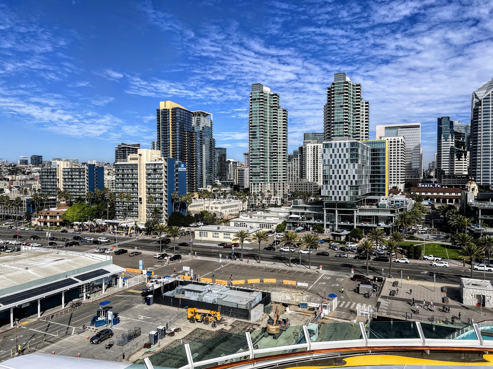
Because most of my life so far, was spent living in the Phoenix, Scottsdale, and Mesa, Arizona, I spent a lot of time visiting the favorite vacation spot for those from the Salt River Valley: San Diego California. Here is a recent photo of the downtown area. See if you can guess where I was when I took this photo.


